A clear view of a complex environment
16 DECEMBER 2025 | By Kristiane Bernhard-Novotny
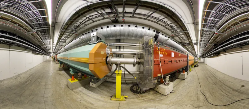
Panoramic picture of a transfer tunnel in the North Area. Credit: N Mandal & N Kahn
The North Area is a place where precision matters. Understanding its layout, recognising equipment and navigating its experimental spaces are essential parts of daily work. While EN-ACE has long maintained its own panorama strategy, which predates the North Area Consolidation project (NA-CONS), the expertise they shared has supported the development of a complementary method tailored to the areas under NA-CONS responsibility. NA-CONS now provides a valuable framework in which many of these panoramas are used to support consolidation activities, even though the overall panorama work extends beyond NA-CONS and serves a broader operational purpose.
These panoramas provide users, collaborators and visitors with an accessible way to explore the facilities. They help teams familiarise themselves with halls, beamlines, power converters and infrastructure before arriving on site, and they offer a virtual alternative during periods when access is restricted.
A Coordinated Effort
Each panorama is taken to give an accurate overview of the environment, allowing viewers to understand equipment placement, spatial relationships and key reference points. The shooting is shaped by practical requests from users, who can ask for specific areas or equipment clusters to be documented so that all relevant labels and details are visible. In addition to responding to these requests, the teams also revisit and update older panoramas approximately every five years to ensure the material remains accurate and useful.
For Naini Mandal, NA-CONS member and one of the project’s photographers, the purpose is clear “Our aim is to make the North Area visible at any time. A clear view of the environment helps teams prepare with confidence before they arrive.”
The creation of each panorama follows a careful and consistent sequence:
- Positioning the camera and tripod, even in areas with uneven or grated flooring, and ensuring correct focus and alignment.
- Capturing four images, spaced 90 degrees apart, while keeping the scene stable and unobstructed.
- Repeating the process at each location to capture equipment positions and labels, access points, corners and service areas.
- Stitching the images using dedicated software to produce a coherent 360-degree view.
- Uploading and linking the panoramas on the GIS portal so that users can navigate them smoothly.
“The panoramas turn complex spaces into something intuitive,” explains Natalya Kahn, Naini Mandal’s colleague and co-photographer. “When users can explore the halls and equipment in advance, it supports both safety and efficiency.”
A Practical Tool For Preparation And Outreach
For incoming users, the panoramas and their annotations offer the chance to become familiar with the environment in advance, which supports safe and efficient work. Technical teams can trace equipment layouts, plan interventions and reduce uncertainties during their first days on site.
For visitors and collaborators, the panoramas offer virtual access to areas that remain restricted during beamtime, helping them understand CERN’s infrastructure without affecting operations.
An Expanding NA-CONS Resource
The dedicated camera is fully integrated into the NA-CONS workflow, and new panoramas are added regularly as the documentation effort progresses across the North Area. The long-term aim is to provide a complete visual catalogue of the experimental spaces.
By making the North Area easier to navigate and understand, this effort supports day-to-day operations and longer-term planning. It also reflects a central goal of NA-CONS: strengthening the experimental environment not only through physical consolidation but also through improved clarity, accessibility and user experience.
Useful links: